
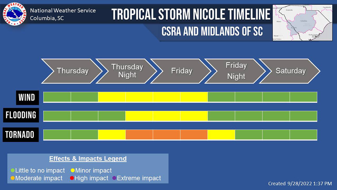
A Tropical Storm Nicole timeline with wind, flood and tornado threat levels (Graphics courtesy of National Weather Service)
Midlands residents should prepare for severe weather, including tornadoes, starting as early as the morning of Thursday, Nov. 9.
Tropical Storm Nicole is forecast to bring potential tornadoes and heavy rain to the Midlands region as it moves across the state Thursday. With the track shifting west just slightly, Tony Petrolito, a meteorologist for the National Weather Service said, the threat for severe weather has increased for eastern South Carolina.
The clearest threats to the Midlands are isolated tornadoes and flash flooding in low-lying areas, said, Derrec Becker, the chief public information officer at the state’s Emergency Management Division
The first bits of rain will come in early Thursday morning with the heaviest rain starting Thursday night and lasting until Friday night, said Dan Miller, another meteorologist at NWS. The threat of tornadoes starts Thursday night and will last until Friday morning.
Becker urges South Carolinians to review their emergency plans now to avoid any potential threats down the line.
“If you get an alert or a warning,” Becker said, “do you have a safety area pre-identified in your house?”
People will receive a warning on their phone from the NWS or via National Oceanic and Atmospheric Administration (NOAA) weather radio prior to the clear warning signs of a tornado, so everyone should have their cell phones fully charged before the threat increases Thursday afternoon, Becker said.
Not everyone has plans in place for these situations.
Marina Moore, a 21-year-old senior at the University of South Carolina, said she knew nothing about the tropical storm, and she doesn’t have an emergency plan.
Petrolito said it’s uncommon for South Carolina to be experiencing tropical storms this late in hurricane season, which ends Nov. 30, largely because the temperature of the ocean water is much lower by this point.
To prepare for the possibility of tornadoes after receiving a warning, the state agency advises to watch for dark, green-ish clouds that look to be rotating, large hail and loud, freight train-like roars. If any of these are present, take shelter immediately and enact your personal emergency plan.
“In most cases, your home can be your best shelter,” Becker said. “But if you don’t feel safe in your home, … find a safe place to ride out the storm for a few hours.”

The National Weather Service held a briefing on Wednesday about the most likely arrival time of tropical-storm-force winds through Florida, Georgia and South Carolina. South Carolina is set to experience tropical-storm-force winds by Friday morning.
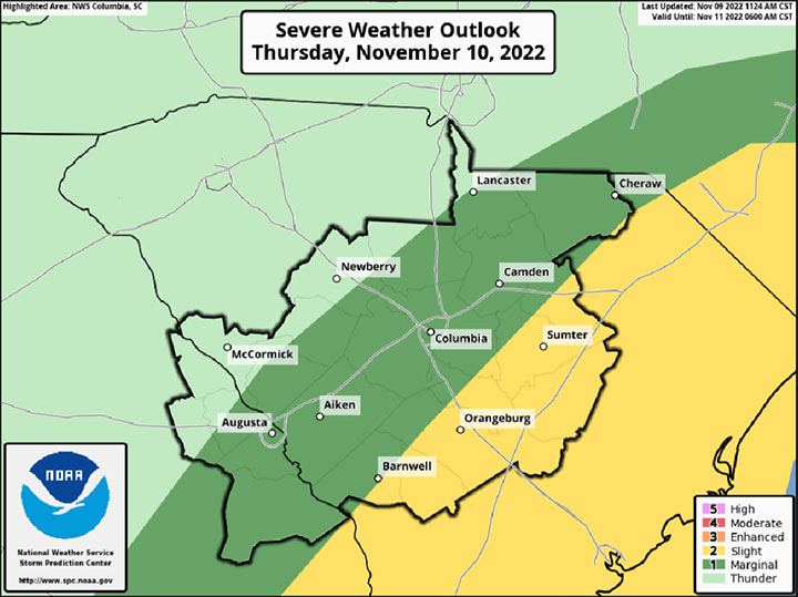
FOR THURSDAY. National Weather Service graphic from briefing Wednesday, Nov. 9 about the tornado threat level Thursday, Nov. 10. The briefing detailed that the main threat of tornadoes will be Thursday evening and night.

FOR FRIDAY. National Weather Service graphic from briefing Wednesday, Nov. 9 about the tornado threat level Friday, Nov. 11. The briefing detailed that the main threat of tornadoes will be Friday morning and afternoon.
