
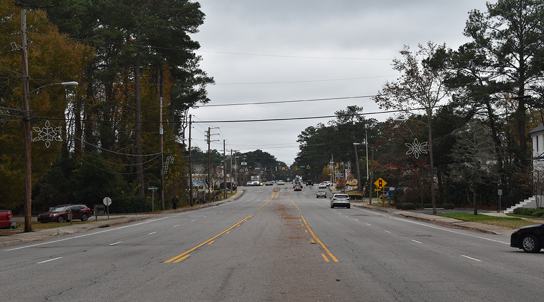
North Trenholm Road in Forest Acres looking toward Forest Drive. North Trenholm was one of the routes driven by volunteers who took the temperature of the road. (Photos by Tyler Fedor, Courtesy of Kirsten Dow and CAPA Strategies)
When Jim Irvin was at law school in the early 1990s, he would often ride his motorcycle from the University of South Carolina’s campus to his home in the nearby Shandon neighborhood.
He said he could feel significant changes in temperatures along his route between the areas that were shaded with trees and the areas that weren’t.
“I would always find myself kind of rushing through the unshaded areas on the motorcycle and onto the shaded streets as much as I could,” said Irvin, who now serves on the city’s Tree and Appearance Commission.
Columbia knows where those unshaded, hot areas are these days, thanks to two USC researchers and some volunteers. Professor Kirsten Dow and doctoral student Grant Farmer created a temperature map of the city this summer at the behest of the Tree and Appearance Commission.
It’s the first time a heat map of Columbia has been made, Irvin said. Dow said she hopes the city can use this to plant more trees to cool areas with extreme heat. Doing so could attract businesses, lower energy bills and lessen the burden on neighborhoods with less access to medical services needed when extreme heat threatens their health.
Dow said the briefing of the interested parties on the data and study would happen more during next year.
“It was important knowing that there was a group in the city who was willing to act on it,” Dow said. She said multiple departments in Columbia government were interested in the study.
Dow said the commission had been thinking about the study for years, as the group was aware the city was losing its tree canopy. Robert Anderson, the director of the public works department, said Columbia loses around 450 trees a year. The department plants around 500 every year. However, many lost trees are mature with canopies. Replacement trees are often saplings that will take decades to create canopies.
“Not just thinking that we know where those warmer areas are, but actually having the data that backs that up, will help us make better-informed decisions,” Irvin said regarding the development of the city and planting of trees, shrubbery and other components of beautification of the city.
Farmer met Dow last year while working on a temperature map for Charleston. The work caught the eye of Dow, who told the Tree and Appearance Commission about the study. When Dow told Farmer about the interest of the commission in heat mapping, Farmer asked to be included.
“Being from South Carolina, I’m pretty familiar with extreme heat and how that works in the state,” Farmer said. “We’re used to just being miserable all the time. So I wanted to know more about how heat impacts Colombia.”
The Columbia study covered 188 square miles, Dow said. She said money to support the study came from national and local groups, such as NOAA and Columbia Green.
While she organized the data, Farmer managed the 40+ volunteers who helped perform the study. The group gathered information over a four-week period during July and August.
The study was comprised of two forms of data gathering. The volunteers drove down 16 preset routes that stretched from Blythewood to Lexington, gathering temperature readings. Dow said the routes accounted for multiple geographic characteristics of areas, such as tree canopy cover and buildings. The other set of data came from stationary sensors placed around Columbia.
The hottest areas were places where asphalt and buildings trap heat and had little to no tree canopy coverage, such as downtown Columbia, Dow said. One surprise, though, was that these areas didn’t cool down at night as much as Dow expected.
“That affects people’s comfort outside,” Dow said. “It affects your energy bills. It affects what you should be doing and how much you should be hydrating, taking care of yourself. It affects people’s willingness to want to be out and doing stuff.”
The temperatures recorded in the study ranged from 72.5 degrees in the morning to 100 degrees in the afternoon.
Columbia saw its hottest temperature since 1958 in June of this year: 103 degrees, according to the Columbia Metropolitan Airport weather station. Columbia’s average temperature is 3.4 degrees higher this year than last, according to The Post and Courier.
The biggest worry of rising heat for Dow is for people suffering from “energy poverty.” Energy poverty means people who live below the poverty line are spending most of their money on cooling and heating costs. Dow said that in Richland County, if you are 50% below the federal poverty line, then 38% of your income goes toward cooling costs.
“If you’re already below the poverty line, then diverting money from other kinds of necessities in order to keep cool is a problem,” Dow said. “It influences access to food security or to other kinds of health care or to educational things.”
Farmer said poorer neighborhoods, which usually have less tree cover, had higher temperatures than other areas they measured.
“It’s going to affect those people greater because they’re already living, possibly in poverty or, like, lower-income neighborhoods,” Farmer said.
The temperature map is also of interest to the city’s public works department. Anderson said the mapping would help protect city workers from the heat by guiding them to plant trees in the hottest areas of the city.
“We have workers out every day no matter what the heat is, whether they’re working on the road or picking up garbage or paving or whatever,” Anderson said.
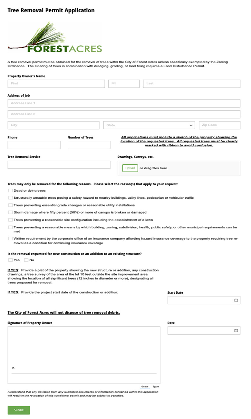
One way the city and local neighborhoods maintain tree canopy coverage is by making people who wish to remove trees apply for it via a permit. Columbia has a tree-density requirement for commercial, institutional and industrial sites.
The city of Forest Acres receives on average 350 to 400 applications for tree removal every year, Shaun Greenwood, the city administrator, said. Roughly 95% of these applications are approved. Among the requirements: The city only approves the removal of certain types of trees that have a trunk four to 12 inches wide or are near Trenholm Road, Forest Drive or Beltline Boulevard.
To protect the tree canopy, Forest Acres requires the replanting of trees relative to the amount removed.
“Forest is in the name,” Greenwood said. “They thought, hey, we need to protect our community property values and our community character to maintain the larger mature trees, and people shouldn’t be able to just cut them down because they don’t like them or because it’s easy.”
Back in Columbia, Irvin said the commission will use the temperature map to focus efforts on where to plant trees. He said creating tree canopy and engaging in the beautification of areas of the city that need it would spur economic development.
Irvin said North Main Street and the Vista are examples of areas that have grown due to beautification efforts, such as planting trees and moving power lines underground.
These two go hand in hand. The fewer power lines that are above ground, the more room trees have to grow and the more shade they can provide to cool the area down. It will also improve walkability, which in turn will get businesses more customers.
“The city invested in North Main,” Irvin said. “Now we’ve got a lot of businesses that are located there. And businesses continue to locate there. And they’re also developing some residential living there.”
Irvin said the data will be used for more than just beautification and the planting of trees, though.
“I think the more awareness people have of, you know, what I’ll call ‘wins’ and improvements that have already occurred, the more they recognize the importance of maintaining that,” Irvin said.
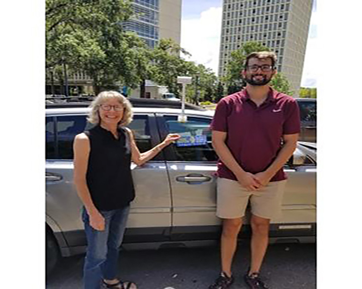
Gwen Geidel, left, and Grant Farmer stand next to a car with a device that recorded temperatures on the preplanned routes. Both helped to organize the study, along with Kirsten Dow.
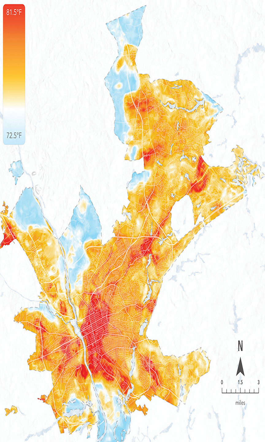
A map of the hottest and coolest areas in Columbia between 6 a.m. to 7 a.m.
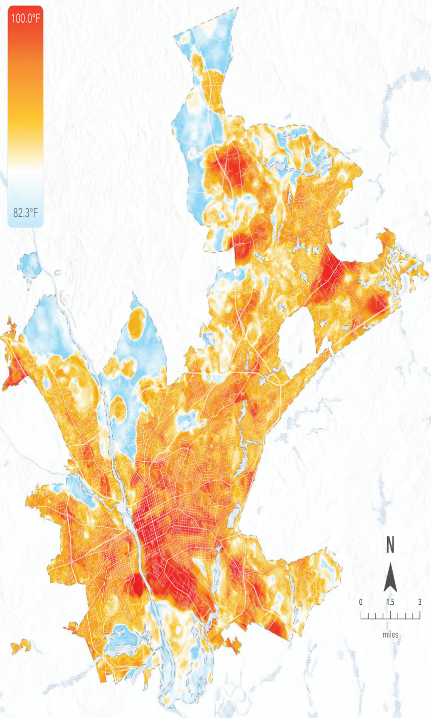
A map of the hottest and coolest areas in Columbia between 3 p.m. and 4 p.m.
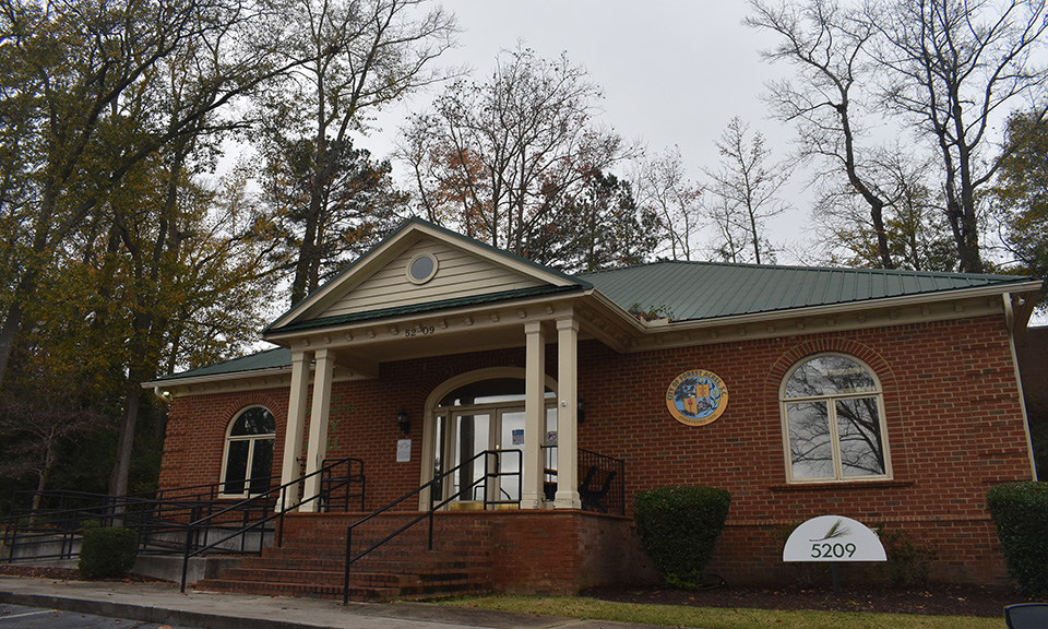
Forest Acres City Hall. People must fill out an application before being allowed to cut down trees.
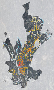
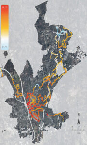
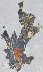
The temperatures along routes in between the hours of 6 a.m. to 7 a.m., 3 p.m. to 4 p.m. and 7 p.m. to 8 p.m.
