
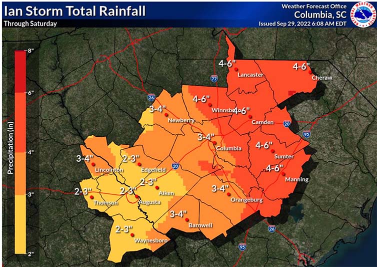
Projected areas of rainfall in the Midlands ahead of Hurricane’s Friday arrival in S.C. (Graphic courtesy of the National Weather Service Columbia)
Ian is predicted to strengthen into a Category 1 hurricane before it makes landfall in South Carolina, possibly along the central or northern coast, the National Weather Service said Thursday afternoon.
And while Ian is expected to return to a tropical storm by the time it reaches Columbia, Midlands residents still should expect strong wind gusts, heavy rainfall and flash flooding Friday day and overnight Friday, NWS Columbia said. The hurricane designation should slightly increase expected wind speeds and rainfall in the Midlands.
The University of South Carolina and many Midlands K-12 schools have called off all classes Friday in anticipation of heavy rainfall and flash flooding from the slow-moving storm. Richland County Government is also closed Friday.
USC is sending buses to its coastal campuses to transport students who want to evacuate to the Upstate, University President Michael Amiridis said on Thursday.
Columbia’s COMET bus service will attempt to run routes as normal but may be delayed because of the weather, COMET representative Blake Gibbons said. Residents may call COMET’s inclement weather hotline at (803) 255 – 7118 for updates.
South Carolina fell under a tropical storm warning Thursday after Hurricane Ian hit Florida as a Category 4 storm and one of the most destructive hurricanes Florida has seen. Ian was downgraded to a tropical storm as of 5 a.m. Thursday, according to the National Hurricane Center.
S.C. Gov. Henry McMaster declared a state of emergency Wednesday afternoon. He decided against ordering a coastal evacuation, saying it would entail “a lot of disruption.”
Initiating a state of emergency allows the state to activate the National Guard and draw from FEMA money as needed. It also means local governments and schools, on the coast and in the Midlands, will make their own decisions about closing or staying open.
“This is not just a coastal event,” said Kim Stenson, director of the S.C. Emergency Management Division. “We expect the storm to impact all of South Carolina in one way.”
The hurricane’s projected path as of Thursday morning will bring Columbia anywhere between 3 to 6 inches of rain through the weekend, according to NWS Columbia.
Gusts could be between 50 mph and 60 mph, the NWS said Thursday, up from the 40 mph to 50 mph it expected Wednesday. That could down trees and power lines. But the potential for tornadoes is low.
It will be a slow-moving storm, projected to travel at 15 mph to 20 mph.
“That’s one of the reasons why we’re thinking some of the heavier rainfall amounts,” a NWS Columbia spokesperson said Wednesday. “If it was moving faster, we’d probably be able to narrow that range down. Fortunately, we’re not expecting anything in the way of what’s going on in Southwest Florida.”
Statewide, flooding is the biggest concern, according to NWS Columbia.
Storm surges in Charleston are expected to be 4 to 7 feet, the National Weather Service said Thursday afternoon. High tide is at noon.
“Run from the water and hide from the wind,” McMaster said during a Wednesday news conference. “That is the rule here. Be sure to know where you are to be prepared.”
Shelters will open Thursday in Charleston and Jasper counties for residents who choose to evacuate. Some Lowcountry bridges may be closed if sustained wind speeds are high enough, S.C. Department of Transportation Director Kristy Hall said.
The Columbia Women’s Shelter and Homeless No More in Columbia are already at capacity after seeing an uptake of people searching for shelter ahead of Ian’s arrival, officials said.
It’s important to buy food, water and gas and have flashlights and first-aid kits on hand in case of a power outage, according to Mike DeSumma, a spokesperson for the Columbia Fire Department.
Columbia Fire Department will monitor wind speeds and water levels and gauge for flash flood threats. Officials want residents to remember that it only takes one foot of water to move a car.
But conditions should improve Saturday, NWS Columbia said.
In Midlands grocery stores, shelves that hold bottled water, flashlights and non-perishable foods were still stocked Wednesday. But as the storm travels closer along the region, more items are expected to sell out.
Residents can refill their medications early with permission from most insurance companies, a Walgreens representative told the Carolina News and Reporter. The Five Points Walgreens store expects larger crowds of people to pick up prescriptions today.
A full list of tips from the S.C. Emergency Management Division on how to best be prepared is available here.
Residents should avoid the nearly 30 roads that are prone to flooding in Columbia, city officials said. Intersections on Blossom, Harden and Wheat streets are especially low-lying and flood more quickly than the rest of the city.
“Whenever we have that prolonged period of heavy rain over a short period of time, we have flooding – and it happens fast,” DeSumma said.
The Columbia fire department is encouraging people to stay home Friday and Saturday but to not cross roads with standing water if they do choose to travel.
“If you come across water in the roadway, do not try to guess how deep it is,” DeSumma said. “Turn your car around, don’t drown.”
City and county firefighters will work with the Columbia Police Department to monitor the flood-prone areas. Officers will be posted where they’re needed to assist with traffic and barricades, city of Columbia spokesperson Jennifer Timmons said in a Tuesday email to the Carolina News and Reporter.
Dams and reservoirs overflowing or bursting are another concern the state is monitoring. But only minor flooding along the Midlands’ rivers is expected, according to NWS Columbia.
Dam and reservoir owners and operators should clear debris from spillways and assess the water level to determine if they need to lower the levels ahead of the storm, according to the S.C. Department of Health and Environmental Control.
Dominion Energy said it has released water from the Lake Murray dam this week as a precaution.
Dominion Energy has crew members stationed throughout its service territory in the state. More than 200 crew members from other service territories have also come down for assistance, spokesperson Matt Long said.
Prisma Health, meanwhile, is preparing its campuses for large amounts of rain and high wind speeds, visitors and team members, according to Tammie Epps, the communications director from Prisma Health.
“Prisma Health stands ready to assist other healthcare facilities that may be impacted by the storm with the temporary relocation of patients or in the requests for equipment or supplies,” Epps said in an email statement.
Essential agencies want people to know that they’ll work no matter what the conditions turn out to be.
“We’re still here, and we’re ready to help,” DeSumma said. “Please call 911 if you have an emergency.”
Editor’s note: Tyler Fedor, Dylan Ortuno, Audrey Elsberry and Shakeem Jones contributed to this report.
